
Very light rains and thundershowers occurred at isolated places in Uttar Pradesh though, and a fresh warning of heavy showers was issued in Himachal Pradesh as the India Meteorological Department (IMD) said heavy to very heavy rainfall is likely in several parts of the country, including the northern region, over the next six-seven days.

The weather system moved west-northwestward and concentrated into a depression on Saturday at 8.30am, close to west of Andaman Islands, the bulletin said.

Above-normal heatwave days are predicted in most parts of central, east and northwest India during this period.

All parts except Northeast may get below-normal rain; govt reiterates assurance on preparations.

El Nino is expected to occur in August-September, but it is unlikely to have any major impact on the monsoon, and the weatherman expects a positive Indian Ocean Dipole, which has a strong influence on rainfall in the country.

"This year, the Southwest Monsoon is likely to set over Kerala on May 31 with a model error of four days," the India meteorological department said on Wednesday.

Data released by the IMD on Thursday showed that the mean minimum temperature (MMT) this December was 7.1 degrees Celsius.

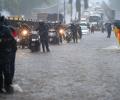
As the heavy rains continued on Wednesday also, Orange alert was sounded in 12 of the 14 districts of the state for the day.

The IMD issued a 'red alert' for Pune district and asked people to take precautions.

The IMD DG said there should not be an impression that climate change leads to rise in the temperature, but on the contrary, it leads to erratic weather.

This should augur well for the rabi crops as delayed withdrawal will leave enough moisture in the soil for early sowing.

The city's 24-hour Air Quality Index, recorded at 4 pm every day, stood at 418, up from 334 the previous day, and it may trigger stringent restrictions under the third stage of the graded response action plan to mitigate hazardous conditions.
'It is the most prone month for the development of cyclones in the pre-monsoon period.'

The local train traffic on the Central and Western Railway routes was mostly normal though the trains were running a few minutes late, railway officials said.

The Mungeshpur weather station recorded a high of 48.8 degrees Celsius, eight notches above the normal. It recorded a minimum temperature of 27.6 degrees Celsius, a notch above the season's average.

Widespread rains lashed parts of Tamil Nadu on Thursday, prompting authorities to declare a holiday for schools in Chennai and many other districts.
The IMD projects total rainfall in the June-September monsoon season as being 99 per cent of the long-period average.

On May 15, the weather office had announced the onset of monsoon over Kerala by May 31.
India has roped in almost all the world's major weather forecasters in its effort to accurately forecast monsoon rains in the next four years.
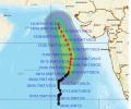
'Very severe cyclonic storm Biparjoy at 2330 hrs IST of 9th June over east-central Arabian Sea near lat 16.0N & long 67.4E. Likely to intensify further & move north-northeastwards during the next 24hrs,' the IMD said in a tweet.

The IMD dispelled fears by forecasting a normal monsoon for June-September. Rainfall is expected to be 98 per cent of the long period average, significantly higher compared to last year's 77 per cent LPA.

The India meteorological department predicted mainly clear skies with heatwave conditions in many parts of Delhi and severe heat wave conditions in other areas.

IMD will present its month-wise and region-wise forecast in June.
West Bengal Chief Minister Mamata Banerjee on Friday said that one person died in the state in cyclone Dana, even as the administration evacuated around 2.16 lakh people from the low-lying areas.

The bounteous monsoon this year has already dumped 1159.4 mm of rainfall in Delhi till Thursday afternoon, the highest since 1964 and the third-highest ever, according to the IMD data

Anything between 96-104 per cent of the LPA is considered as normal rainfall while precipitation in the range of 104-110 per cent is termed 'above normal'
A Red alert, indicating heavy to very heavy rains of over 20 cm in 24 hours, has been sounded for Thiruvananthapuram, Kollam, Pathnamthitta and Alappuzha districts on December 3, while Orange alert (6 cm to 20 cm rains)for Kottayam, Ernakulam and Idukki districts the same day.

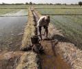
Sowing had started on a sluggish note in several parts of the country because of delay in the onset of the monsoon but has picked up pace subsequently as the rains progressed and performed appreciably well in August.

Officials in the weather department said the monsoon is expected to be below normal because of the El-Nino effect.
Gross Value Added (GVA) growth in agriculture and allied activities in the first quarter of the 2024-25 financial year (Q1FY25) dipped to 2.7 per cent at constant prices from 4.2 per cent in Q1FY24 due to a drop in output of some crops following heatwave in the main growing months. Low post-monsoon rains, which dried most of the reservoirs in several states across the country, also impacted the production of many crops. At current prices, the growth was estimated at 8.5 per cent as against 4.1 per cent in Q1FY24 due to a spike in food inflation during the April to June months of FY25.

After churning across the Arabian Sea for more than 10 days, Biparjoy made landfall near Jakhau Port in Gujarat on Thursday.

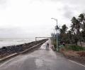
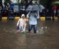
Heavy rains had battered the metropolis on Sunday and Monday as well.

Western Railway stated that local train services were running normally on Monday morning, however, commuters claimed trains were running late by 5 to 10 minutes.
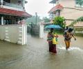
The heavy rains led to water level in various dams in the state rising to the red alert mark, prompting the government to open one of the shutters of Cheruthoni dam of Idukki reservoir in the afternoon.

The southwest monsoon which reached the country on May 30 well within its normal onset date

Spurred by cyclone Remal, the southwest monsoon set in over the Kerala coast and parts of the northeast on Thursday, a day earlier than forecast by the weather office.

The news will augur well for the country as large parts have been witnessing agriculture distress and water levels in reservoirs in west and south India have dipped to low levels.

While the Aam Aadmi Party is contesting on four seats, the Congress has fielded candidates for the remaining three seats.
The met department said that rainfall in August is projected to be within the normal range at 97% of LPA. In August and September, India receives around 43 mm of rainfall.

There is a definite attempt to put the landslides on the backburner because news of them and climate change worry Wayanad's tourism and real estate businesses greatly. Whatever I experienced of Wayanad's 2024 by-elections; the July landslides were not a burning issue, observes Shyam G Menon.